
-
 Distance
:
720 km (13 stages)
Distance
:
720 km (13 stages)
-
 Elevation gain
:
15,000-m ascent | 15,000-m descent
Elevation gain
:
15,000-m ascent | 15,000-m descent
-
 Starting point
:
Rorschach
Starting point
:
Rorschach
-
 Finish
:
Lausanne
Finish
:
Lausanne
The Herzroute subscribes to the motto “The journey is the destination”. The route begins in Lausanne on the shores of Lake Geneva and ends in Rohrschach on Lake Constance (or vice versa). Divided into different stages, it leads through varied landscapes and over the rolling terrain of the Alpine foothills to fantastic lookout points. Every time you crest a hill, new valleys open up before you – each with its own distinctive charm. Speaking of charm, the third stage of the Herzroute begins in the historic little city of Laupen and takes you to Thun via the scenic Bütschelegg mountain in the Gantrisch Nature Park. This is also where the fourth stage begins, which leads past green meadows and grazing goats through the forests of Eriz to Langnau in the Emmental valley.
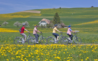
The Herzroute is particularly suitable for cyclists who prefer to take it easy on e-bikes, making it accessible to all ages and fitness levels. Is your battery running low? Don’t worry, there are several stations along the way where you can replace your bike’s battery and find some fuel of your own as well.
-
Tipp
Take a short break on Stage 11: Recharge your own batteries with an afternoon snack in the tranquil Riggisberg castle garden.
-
Route information
Location All over Switzerland Distance 720 km (13 stages) Elevation gain 15,000-m ascent | 15,000-m descent Starting point Rorschach Finish Lausanne Route All over Switzerland Route conditions Difficult (without motorised bike) Directions Arrive in Lausanne, return from Rorschach Comments The stages can be ridden in either direction and are marked as Route 99 all along the way. There are e-bikes available for rent at various locations. Reservations are strongly advised. 🗺️ Map
⛰️ Elevation profile
🚴 More infoStages 8 to 11 of the Herzroute lead through the idyllic Emmental valley and are ideal for day trips.
Stage 8
Location Emmental and Lucerne Distance 63 km Elevation gain 1,250 m ascent | 1,250 m descent Starting point Willisau Finish Burgdorf Route Willisau–Zell LU–Hüswi–Gondiswil–Madiswil–Rütschelen–Linde–Lünschberg–Häcklige–Affoltern i.E.–Schufelbüel–Brandishueb–Hasle–Burgdorf Route conditions Difficult (without motorised bike) Directions Arrive in Willisau, return from Burgdorf 🗺️ Map
⛰️ Elevation profileStage 9
Location Emmental Distance 45 km Elevation gain 1’040 m ascent | 900 m descent Starting point Burgdorf Finish Langnau i.E. Route Burgdorf–Oberburg–Dieterswald–Luterbach–Mänziwilegg–Walkringen–Arnisäge–Blase–Signau–Langnau i.E. Route conditions Difficult (without motorised bike) Directions Arrive in Burgdorf, return from Langnau i.E. 🗺️ Map
⛰️ Elevation profileStage 10
Location Bernese Oberland and Emmental Distance 72 km Elevation gain 1’760m ascent | 1’870m descent Starting point Langnau i.E. Finish Thun Route Langnau i.E.– Signau–Röthenbach i.E.–Bätterich–Schwarzenegg–Eriz–Horrenbach–Schwendi–Steffisburg–Thun Route conditions Difficult (without motorised bike) Directions Arrive in Langnau i.E., return from Thun 🗺️ Map
⛰️ Elevation profileStage 11
Location Laupen Distance 64 km Elevation gain 1’030m ascent | 1’100m descent Starting point Thun Finish Laupen Route Thun–Burgistein–Riggisberg–Bütschelegg–Niederscherli–Thörishaus–Laupen Route conditions Difficult (without motorised bike) Directions Arrive in Thun, return from Laupen 🗺️ Map
⛰️ Elevation profile
-
SchweizMobil
